Bonneville Shoreline Trail
 Bonneville Shoreline Trail

Section: Green Canyon-Logan Canyon
Last updated: July 15, 2020
What is the Bonneville Shoreline Trail?
The Bonneville Shoreline Trail is a trail that follows the shoreline of the ancient Lake Bonneville. This trail is hoped to one day be 280 miles long. It will stretch from the Idaho-Utah border, down to Nephi, Utah. At this moment in time, a little over 100 miles of trail is maintained and considered part of The Bonneville Shoreline Trail. For more information including maps, geology, and history, click here. Today, I will only be focusing on the part of the trail which reaches from Green Canyon to Logan Canyon. This section of the trail is almost 4 miles in length and gains only 593 feet of elevation.
Directions-

To get to this section of the Bonneville Shoreline trail, you can go one of two ways. The first option is going to Green Canyon and hiking towards Logan Canyon. This route is the route that I took and was amazed at the views! To get to Green Canyon is super simple. Simply drive into Logan, Utah till you get to 1800 North. You turn left onto this road and take it till the end. Once you are at the end of 1800 N, turn left again and turn onto 1900 N. Follow this road to the end and it will lead you to the mouth of Green Canyon.
At the mouth of Green Canyon, there is also a park called: King's Nature Park. This park has a catch and release pond, a small hike in the park, and has a Pavillion you could eat lunch at. 
To get to the Logan Canyon starting point, you drive into Logan, Utah, and go to 400 North. Once on 400 North, you will start going up a big hill. Once you start going down this hill be aware that you will need to stop at the bottom to park in the First Dam parking lot. Once in the parking lot go through the tunnel, hike up the hill, and go straight.
Both areas have multiple trailheads leading from each area and can be crowded. Some trails include Green Canyon, River Side Trail, and the High Line Trail.


The Hike itself-
First I will talk about the hike from Green Canyon to Logan Canyon. If you start from Green Canyon it is pretty much all uphill other than about 0.25 miles at the end going into Logan Canyon. This part is downhill and is a bit steep in some spots.
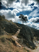
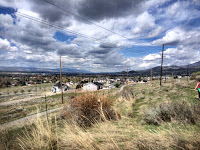
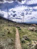
When you start the hike there is a huge sign which says you are on the Bonneville Shoreline Trail. This is how you know you are going the right way. The trail features great views of the valley and you can get some great panoramics from on the trail. The trail is a dirt/gravel trail and is compact. It's super easy to keep your footing and not fall.
Now, Logan Canyon to Green Canyon. To get the hike you need to park in the First Dam parking lot and walk up the hill. Make sure when you get to the top of the hill you go straight not right. The right leads to the High Line Trail, we want the Bonneville Shoreline Trail.
Once you have started on the trail, you will be walking up a hill which could be considered a little steep. Once you reach the top of this hill it is mostly downhill or flat. You will have the same views of the valley, just walking in a different direction.
Tips-
This trail has little to no shade. Make sure you bring more than enough water and don't hike when it's too hot. Bikers can also use this trail and when I hiked it many bikers were riding it. For bikers, this trail looked in really good condition. Make sure to be aware of bikers and others hiking on the trail.

Thoughts-
This trail was an excellent trail and I hope that more of the trail will be available to people in the coming days. If you would like to contribute to this cause, click here and you could help benefit the trail greatly.
From this trail, you could make a big loop consisting of the Bonneville Shoreline Trail, Highline Trail, and the River Side Trail, it would be about nine miles. Many people also make a bigger loop consisting of climbing over the mountain from Green Canyon and seeing the wind caves and hiking the River Side Trail.
Have you ever gone on this trail? If you have share your stories down below in the comments! Have any questions? Feel free to ask those too! If you liked this post it would be super great if you could share on Pinterest or with your friends. It really helps me out and helps me make more posts just like this one.


Comments
Post a Comment